Throwback Thursday: Tavern Troubles (Part IV)
- Setting the Scene
- Which Road Was the âPublic Roadâ?
- Scullâs Map with Major Roads of Chester County
- So Where Was Samuel Ogdenâs Tavern?
- The White Horse Tavern Along Swedesford Road
- Conestoga Road
- The 1703 Road
- Roads to Yellow Springs
- Thomas Jerman and His Mill
- Who Was Edward Grizell?
- But This Is Edgemont Township, in Delaware County?
- Pikeâs Land
- So... Samuel Ogden?
- âTill Next Week
- Featured History Event at Historic Yellow Springs
Roads, Roads, Roads: Still Tracing the Long-forgotten Trails of Colonial Taverns
Setting the Scene
In our last post, we traced early records connected to the Yellow Springs Tavern. We found a possible connection to the Pritchard family, although genealogy must confirm their relationships. We also ruled out Jonathan Ogden and James Trego as keepers of the Yellow Springs Tavern. Their records instead connect them to the Boar’s Head Inn in Chester.
Samuel Ogden remains a mystery. His 1727 tavern petition describes an establishment along a “public road,” but it never identifies the road or its location.
This week, we followed the roads themselves. We compared historical accounts of early Chester County highways with William Scull’s 1770 map of Pennsylvania. We also searched for taverns along these routes and examined smaller roads near Yellow Springs. Could these forgotten trails help us locate Samuel Ogden’s proposed tavern?
Which Road Was the “Public Road”?
We turned to a 1986 article by Grace Winthrope in the Tredyffrin Easttown Historical Society’s History Quarterly. Winthrope traces the development of early roads throughout Chester County.
We used her research to annotate William Scull’s 1770 map, the oldest and most detailed map of Pennsylvania we found for this project. Scull’s map identifies major routes but leaves out many smaller roads.
By comparing these sources, we could narrow our search to roads that existed during the 1720s. The following ten routes provide a broader picture of colonial transportation and help explain where Samuel Ogden might have operated.


Scull’s Map with Major Roads of Chester County
Road 1: King’s Highway
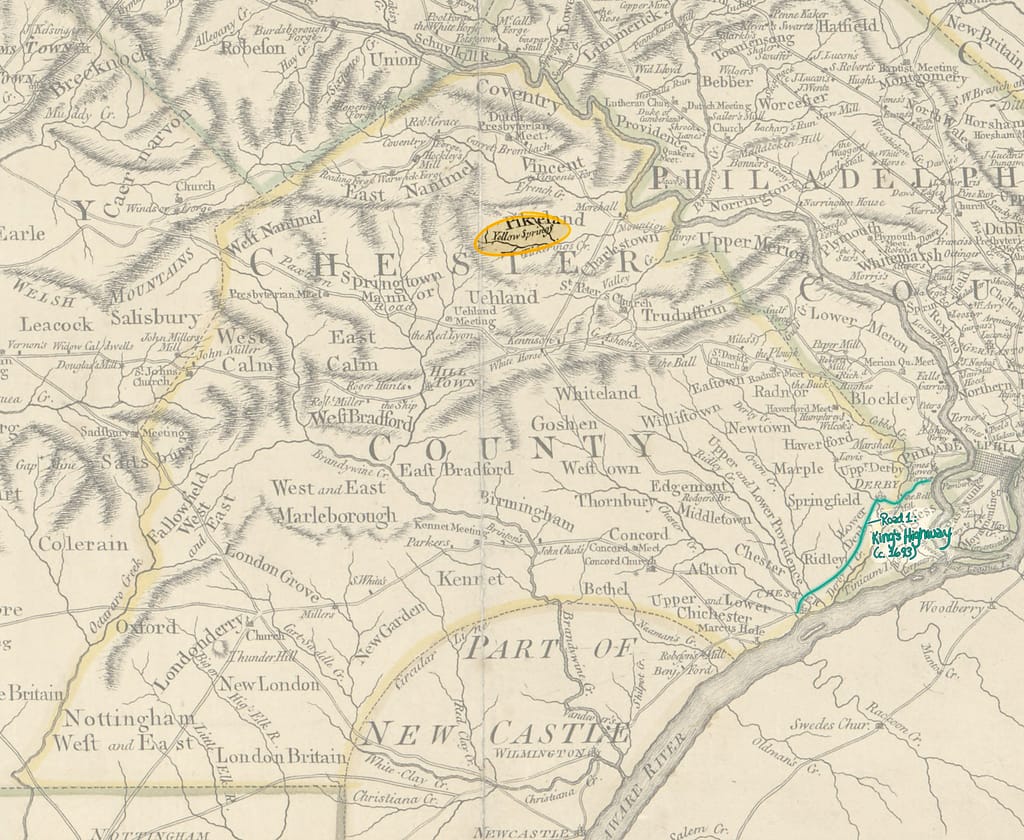
The King’s Highway became Pennsylvania’s first extensive, formally established colonial highway. Its name honored King Charles II of England, and parts of the route took shape before William Penn arrived.
Upland Court records first mention the highway in 1678. The court ordered a road between Cobbs Creek Mill and Caleb Pusey’s Mill along Chester Creek. After officials surveyed and laid out Upland, now Chester, they extended the route to the town.
As European settlement expanded south and west, the highway grew with it. By 1693, the road reached south through the “Lower Counties,” now Delaware and Maryland.
Today, US Route 13 follows parts of the old route. These include Chester Pike and Main Street through Darby, Sharon Hill, and Ridley.
Road 2: Edgemont Road
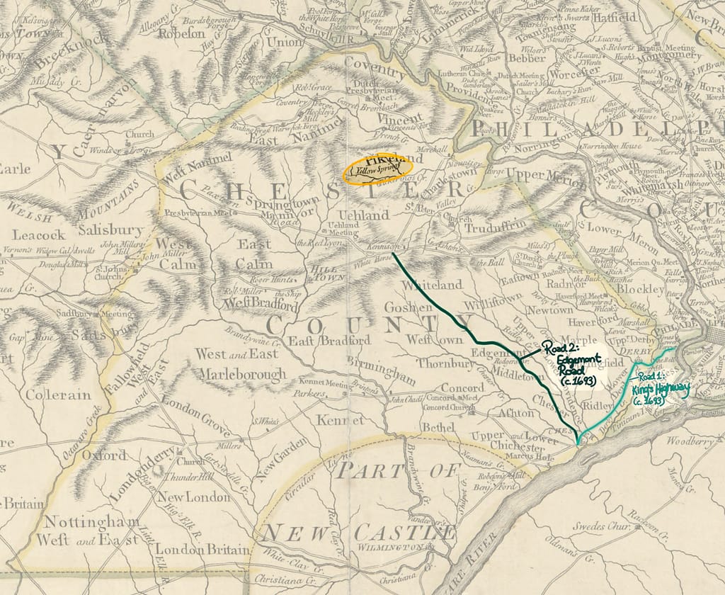
The Edgemont Great Road became the second officially established “Great Road” in colonial Chester County. Records trace its origins to at least 1687, when it connected settlements around Edgemont with the King’s Highway.
On October 4, 1687, Chester Court ordered officials to survey the route. Part of it followed the Providence Great Road, which officials had laid out in 1684. Today, part of that route corresponds to PA Route 252. On October 25, the Grand Jury established the closely linked Concord Road, connecting the Concord settlement to the same road network.
Quaker and Welsh settlers continued moving inland toward the fertile Chester Valley. Officials extended Edgemont Road in 1693, partly because large limestone deposits beneath the Great Valley made the area economically important.
Today, PA Route 352 follows much of the route established in 1693. Other parts of this historic road network include Chester Road, Middletown Road, Concord Avenue, and Edgemont Avenue.
Road 3: 1703 Road
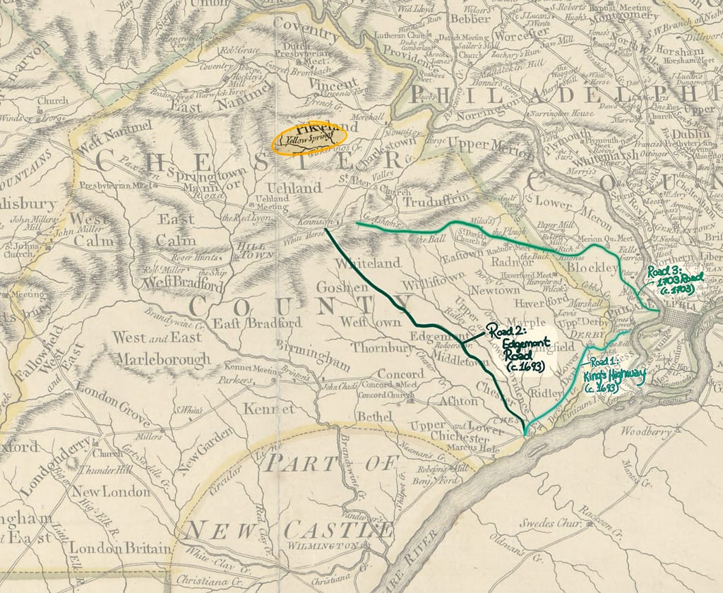
The road established in 1703 connected settlements near Philadelphia with communities farther inland. Today, parts of its route correspond to Goshen Road, Haverford Road, and Haverford Avenue.
In early 1703, prominent Quaker settlers petitioned the Pennsylvania Provincial Council. They called themselves the “principal inhabitants of ye Welsh Tract,” a large settlement area that included parts of present-day Pikeland and Vincent townships.
The settlers wanted an official highway connecting their scattered agricultural communities with Philadelphia’s markets. The Council approved their request.
The planned route linked existing landmarks. It began near William Powell’s Ferry on the west side of the Schuylkill River, passed Haverford Meeting House, and continued toward settlements along Brandywine Creek.
Road 4: Conestoga Road
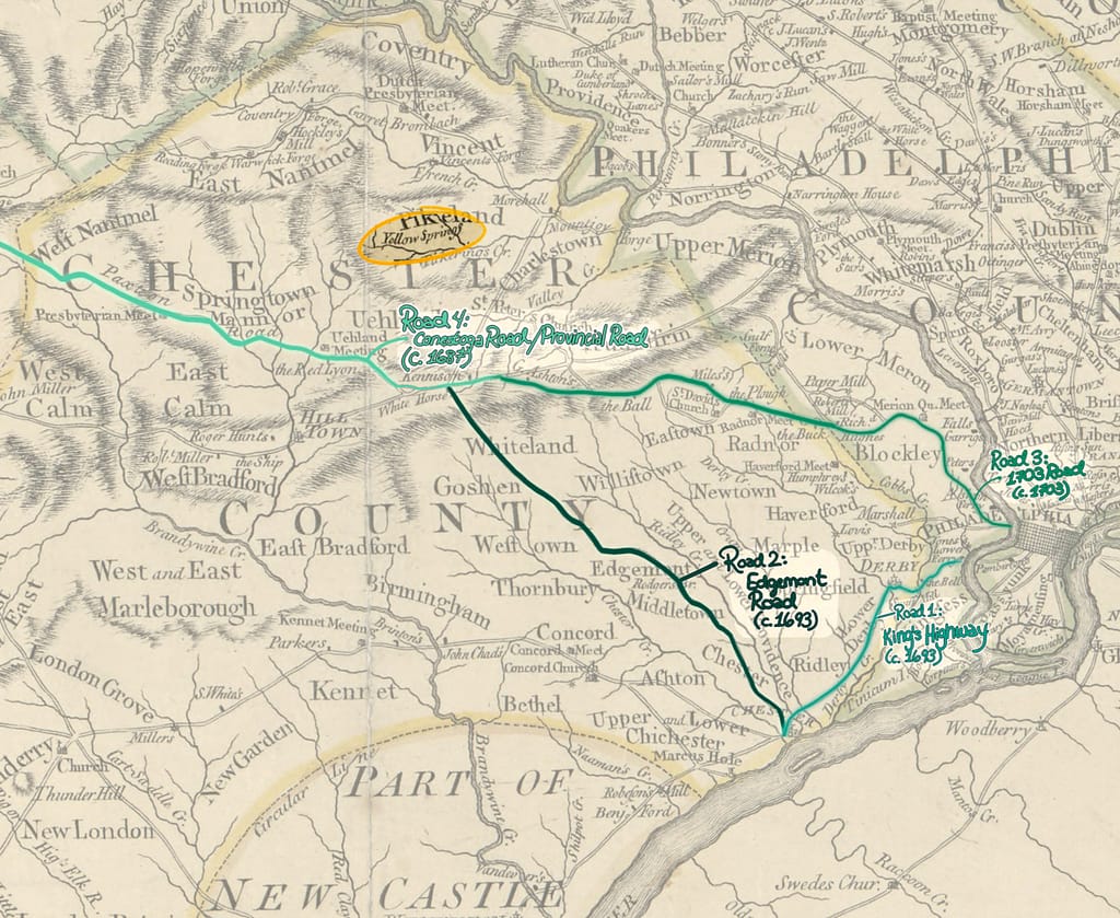
Conestoga Road, also called the Provincial Road, became one of the earliest major highways across what is now Chester County. Before European colonists widened it, Lenape and other Indigenous peoples used a footpath associated with the Allegheny Path.
During the late 1600s and early 1700s, Welsh and English settlers moved into the Welsh Tract, a 40,000-acre area near present-day Pikeland and Vincent townships. They widened parts of the old path to accommodate horses and wagons.
By 1687, officials had laid out a road beginning in Philadelphia. The route gradually extended west toward the Conestoga settlements along the Susquehanna River. Records show it reaching places such as Strafford and Downingtown by 1720 and 1721.
The road connected inland farms and gristmills with Philadelphia’s markets. It also relates to a land sale we discussed in our previous post. In November 1727, Peter Lloyd sought to sell land off Conestoga Road.
In 1733, colonial officials designated Conestoga Road a “King’s Highway.” This designation gave the colonial government responsibility for funding and maintaining the route rather than leaving those duties to local townships.
Road 5: Lancaster Road or Great Road
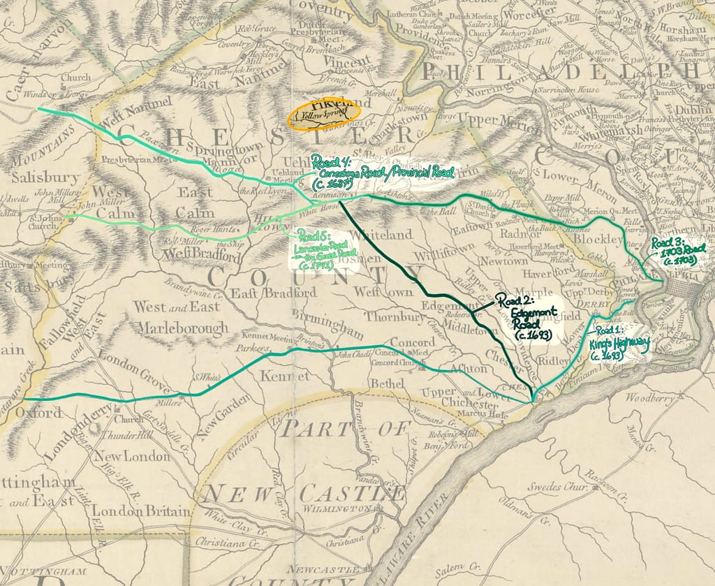
Conestoga Road and the 1703 Road eventually joined into a connected route. Meanwhile, Lancaster grew into a major inland settlement that needed better connections with the surrounding road network.
Lancaster County separated from Chester County on May 10, 1729. At that time, Hickory Town, the settlement’s central town, had about fifteen permanent residents. Farmers had settled much of the surrounding area during the 1720s.
By 1741, Lancaster had grown into what historical records described as a “good-sized settlement” with about 3,500 people. Residents had sought separation because West Chester, then the county seat, lay too far away for effective communication and legislation. By 1742, Lancaster had become a borough with 270 houses and 750 inhabitants.
A new branch connected Lancaster directly to Conestoga Road. For this post, we call that branch the original Lancaster Road. After 1741, it joined the 1703 Road, and people increasingly called the combined route Lancaster Road or the Great Road.
The Lancaster Road on Scull’s map therefore represents more than a newly constructed highway. Its name reflects Lancaster’s growth and the older roads that connected it with Philadelphia.
Road 6: Providence Road
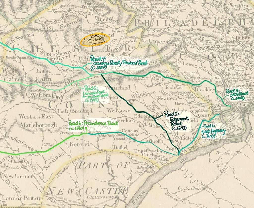
Providence Road dates to 1710. The route ran from the Chester Court House, past Providence Meeting House, and into Whiteland.
Travelers used this corridor long before officials established it as a formal road. Historical accounts suggest that it followed an older Lenape trail, which Indigenous people used extensively before European settlers displaced them from the area.
Providence Road later became important to our research because records from around 1730 connect an extension of the road with Richard Pritchard’s property near Yellow Springs.
Road 7: Marlborough Road

Goshen Road dates to 1719. It ran from Goshen Mill past the “Old Square,” now Newtown Square, where it met Providence Road.
That same year, William Penn laid out Marlborough Street Road. It ran about five miles from the Pennsbury Township line to Marlborough Meeting House.
Settlers soon extended the road in both directions. Today, it forms part of Street Road, also known as PA Route 926.
Road 8: Swedesford Road

In 1724, the Provincial Council ordered officials to open a road through the Great Valley. The route crossed the Schuylkill River at Swede’s Ford, just below present-day Norristown, then continued west through Chester Valley into Whiteland.
Travelers knew this route as Swedesford Road. The petition supporting the project described it as “the most convenient for the publick,” especially for the Baptist congregation. The proposed route would also cause as little damage to private property as possible.
This road matters because it existed during Samuel Ogden’s lifetime. We also found a tavern along it that deserves closer attention.
Road 9: Nutt Road
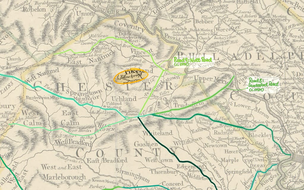
Around 1735, officials established a road in East Nantmeal Township to carry iron from local furnaces toward Valley Forge. The route crossed Warwick and Vincent townships and connected with an older Indigenous trail near the mouth of Pickering Creek.
From there, the road passed Yellow Springs on its way to Valley Forge and eventually Philadelphia. People named it Nutt Road after the founder of the iron furnaces.
Today, PA Route 23 follows much of this historic route. However, Nutt Road dates to after Samuel Ogden’s 1727 petition, so it cannot identify the road he originally meant.
Road 10: The 1748 Road
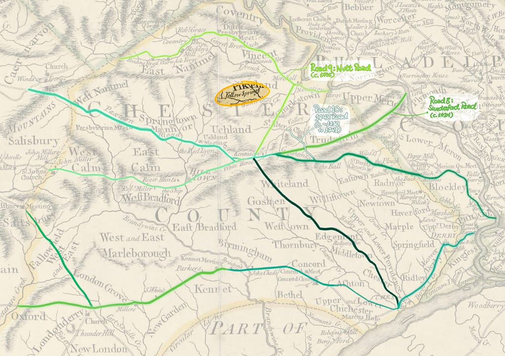
The 1748 Road brought several older routes together under one name. It incorporated the original Paxtang Road, which ran from Tredyffrin toward Thomas Jarman’s Mill, and part of the expanded Conestoga Road known as the Philadelphia Wagon Road.
Paxtang Road followed an older Indigenous trail from the Susquehanna River in Paxtang Township into Honey Brook. It continued through Uwchlan, past the Meeting House, and toward its intersection with Conestoga Road near the White Horse Tavern.
Earlier Tredyffrin records reveal a network of older roads. The township’s first Docket Book entry, from 1710, describes a road from Thomas Jarman’s Mill to the Great Road running from Radnor toward Philadelphia. A 1716 entry describes another route through Tredyffrin, Easttown, and Newtown. That road began at Jarman’s Mill, on Edward Hughes’s land, and ended at Newtown Meeting House.
A separate 1748 route began where the Provincial Road reached the end of George Aston’s land. It ended at the Episcopal Church Burying Ground in the Valley, crossing older roads such as Conestoga and Provincial roads.
These connections show how colonial travelers relied on a growing network rather than a single, fixed set of highways.
So Where Was Samuel Ogden’s Tavern?
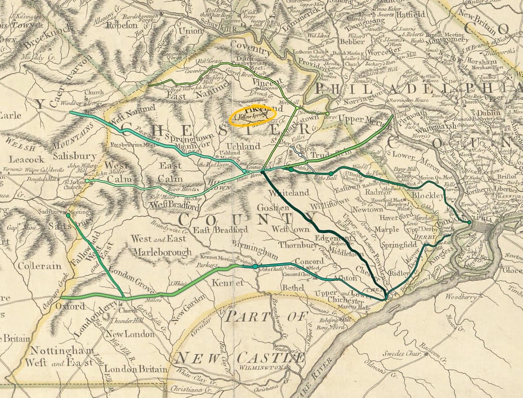
Scull’s map helps us understand Pennsylvania’s major roads by 1770, but it leaves out many local routes. We must also account for changing road names and connections.
Samuel Ogden’s 1727 petition refers to a “public road.” Based on our research, four routes deserve attention: Swedesford Road, the Lancaster Road route, Conestoga Road, and the 1703 Road.
The Lancaster Road name requires particular care. Scull’s map reflects the later merger of older routes, including the 1703 Road. People increasingly called the combined route Lancaster Road or the Great Road after 1741.
In 1789, Philadelphia surgeon and Revolutionary War figure Dr. Benjamin Rush recalled seeing fifty to one hundred Conestoga wagons travel the road in a single day. Many belonged to German immigrant farmers, like those who settled around Yellow Springs.
The Great Lancaster Road remained an important regional route until the Lancaster Turnpike opened in 1794. Even then, the turnpike followed the older road through many places.
We next searched for taverns along our four candidate routes. Our first lead came from Swedesford Road.
The White Horse Tavern Along Swedesford Road
The White Horse Tavern may have operated as early as 1721. According to the modern website’s historical timeline, James Thomas ran it first. Edward Kennison then operated the tavern from 1722 through 1734, and James Trego took over in 1735.
This Trego appears to be the same James Trego connected to Jonathan Ogden and the Boar’s Head Inn in Chester during 1727. The records suggest that Trego became an established innkeeper who managed several properties.
Trego also acquired the Washington House, another old public house in Chester, now in Delaware County. He purchased that property in 1727 and held it until his death around 1745.
These records do not place Samuel Ogden at the Boar’s Head Inn. They also give us no reason to identify him as the White Horse Tavern’s keeper. Kennison operated the White Horse during 1727, while Trego took over in 1735.
Trego’s properties suggest that he built a substantial local business over time. However, ruling out these establishments does not eliminate Samuel Ogden from our search.
Conestoga Road
During the 1720s, Conestoga Road ran northwest from Philadelphia through the Welsh Tract toward Brandywine Creek. It followed an older Indigenous trading route associated with the Allegheny Path.
By 1721, the road reached Thomas Moore’s Mill in present-day Downingtown. It continued west over time and eventually connected with the 1703 Road, creating the Great Lancaster Road in 1741.
Our research uncovered several taverns or licensed houses associated with Conestoga Road:
- Edward Thomas’s Tavern stood near St. David’s Church in Radnor. Records date its establishment to 1717.
- Thomas Moore’s Tavern stood near his mill along Brandywine Creek. It reportedly opened in 1717 to serve fur traders, proprietary officials, and European settlers crossing the river.
- Joseph Cloud operated an unnamed licensed house in Caln. The 1719–1720 Caln Tax List connects him with Thomas Moore’s Tavern.
Other well-known establishments have different histories. Samuel Rees and his wife, Littice, opened the Buck Tavern sometime between 1732 and 1740. Robert Richardson operated the Blue Ball Inn by 1735. People also called that establishment the Halfway House and later the Sign of the Ball.
The Three Tuns presents a less certain timeline. One account dates its construction to before 1730, and the tavern later took the name Prince of Wales. Records associate it with Richard Hughes rather than Samuel Ogden.
None of these records places Ogden at one of these properties. We therefore turned to the 1703 Road and the sections later incorporated into Lancaster Road.
The 1703 Road
Because the 1703 Road eventually joined Lancaster Road, we are examining their routes together when considering the 1720s. The early road ran west from William Powell’s Ferry, past Haverford Meeting House, and toward settlements along Brandywine Creek.
Charles R. Barker’s study of Colonial Taverns of Lower Merion explains that workers opened the western route in separate sections. These included Merion Meeting House to Radnor, Merion Meeting House to Powell’s Ferry, Radnor to Moore’s Mill, and later extensions farther west.
We found four taverns that records connect with this road network by 1727:
- George Aston’s Tavern stood near present-day Downingtown and Caln. Records place it there as early as 1726. A 1918 Pennsylvania Magazine article traces the property after Aston’s death in 1738 and its sale to Roger Hunt in 1739.
- The Sign of the Plow stood in Radnor. David Evans operated it as early as 1726.
- The Red Lion Inn, also called the Red Lyon, stood in present-day Lionville, Uwchlan Township. Records identify James Pugh as its keeper in 1727.
- The Fox Chase Inn, also known as Joseph Hawley’s House, stood in modern-day Newtown Square. Records connect it with Joseph Hawley and reference it by 1727.
A 1767 survey lists Aston’s tavern among many landmarks. These include the Sign of the Wagon, Warwick Miller’s store, the Sign of the Ship, John Downing’s tavern, the Old White Horse, Rising Sun, Sign of the Ball, Radnor Meeting House, Plow, Horse and Groom, Rose and Crown, Prince of Wales, Merion Meeting House, Black Horse Tavern, and Schuylkill River.
These records help us place taverns along the developing route, but none connects Samuel Ogden with one of these establishments. We therefore shifted our attention to smaller roads near Yellow Springs.
Roads to Yellow Springs
The Chester County Archives’ Index of Road Papers, 1686–1882 offers a more promising lead. By 1716, officials had laid out roads through the area that later became Pikeland. However, the record does not name Yellow Springs or prove the road passed the springs.
A 1718 entry describes a road from John and Thomas Moore’s Mill in Caln to the road running from Richard Woodward’s tavern toward Concord. We do not know where Woodward’s tavern stood. His surname resembles Richard Woodworth’s, one of our remaining candidates, so we will keep that possibility in mind.
A 1724 court record provides a stronger geographical connection. It describes a public road beginning at Pickering Creek, on Joseph Pike’s land near Richard Pritchard’s property, and continuing to Thomas Jerman’s Mill in Tredyffrin.

A 1730 record connects Richard Pritchard’s land with an extension of Providence Road.
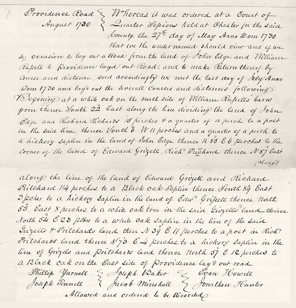
The index also records a road from 1736. It began at the Pickering Creek road near Rees Pritchard’s land and headed toward the Great Valley. There, it met another road linking George Ashbridge’s Mill with Conestoga Road.
These smaller routes connected local properties with major highways. The 1724 record confirms that a public road reached the Yellow Springs area before Samuel Ogden’s 1727 petition. Yellow Springs therefore remains a plausible location for his proposed tavern.
Thomas Jerman and His Mill
Our road research also brought us back to Thomas Jerman’s Great Valley Mill. We first encountered Jerman in Franklin L. Burns’s 1944 History Quarterly article. Local historian Carla Herkner later shared additional information about Jerman and the area’s mills.
Carla sent us a pencil sketch of the Great Valley Mill. Her grade-school friend, Richard Ayers, had received it from his grandfather, artist Henry Morland Williams. Williams drew the scene in 1934. He enjoyed visiting historic places throughout Chester County and sketched many of them.

Local lore also connects Jerman with Pickering Creek through his daughter Elizabeth. Between 1714 and 1719, Elizabeth and her new husband reportedly eloped to a cabin in the wilderness along the creek. The location lay near today’s Anderson Farm Road in Phoenixville.
Historic Yellow Springs also sits along the South Branch of Pickering Creek, near a tributary stream.
We still do not know the precise location of Richard Pritchard’s property in 1724. Records place it near Pickering Creek and land that belonged to Joseph Pike. By 1730, Providence Road connected the area between Pritchard’s property and Edward Grizell’s land.
That second name opened another line of inquiry.
Who Was Edward Grizell?
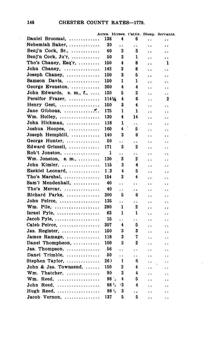
We struggled to identify Edward Grizell in records from around 1730. The earliest similar name we found appeared in the Proprietary Tax Lists of the County of Chester, published in 1897. This later source lists an Edward Grizzell who owned 171 acres somewhere in Chester County in 1779.
A Delaware County history archive offers another lead. Its account of 1790 tax records lists Edward Grissell with 200 acres in Middletown Township. Elisha Grissell also held 100 acres there, and the two men may have been related.
Elsewhere in this project, we found a source about Isaac Taylor and Elisha Gatchel. Maryland authorities took both men prisoner during the 1720s. Taylor surveyed the area later known as Yellow Springs for his 1721 map. Gatchel’s name may represent another spelling of Grissell, or he may have been a close relative. We cannot confirm either possibility.
We initially thought we would need to trace the entire Grissell, Grizzell, Grizell, and Gatchel family. Then we found a useful 1738 tax index in the Delaware County Historical Archives.
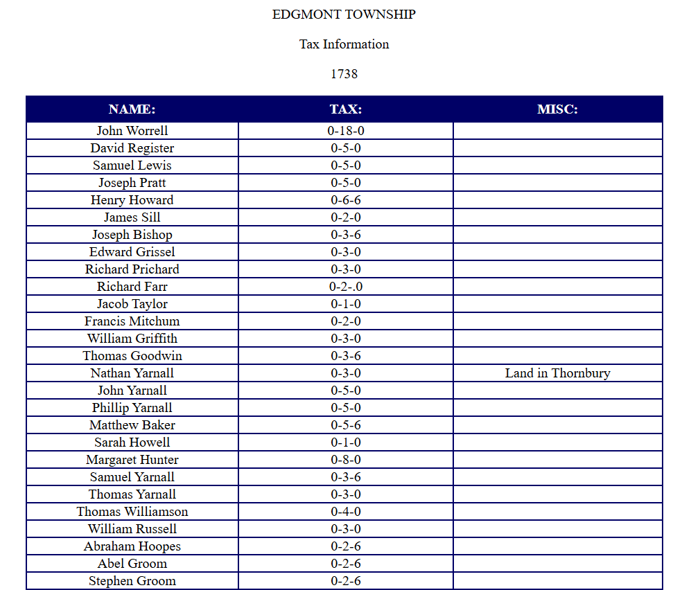
The index lists Edward Grissel and Richard Pritchard, with Pritchard directly below Grissel. Their appearance together supports our hypothesis that this Edward Grissel may be the man associated with Pritchard’s property in 1730.
The same index lists Samuel Lewis, whom records connect with the Yellow Springs Tavern in 1751. These familiar names make the index especially interesting, but they raise an obvious question: why do these records place them in Edgemont Township?
But This Is Edgemont Township, in Delaware County?
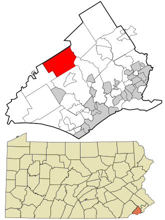

At first, these tax records seem to place Edward Grissell, Richard Pritchard, and Samuel Lewis far from Yellow Springs. The Delaware County archive identifies the records with Edgemont Township. However, modern county boundaries can mislead us when we study colonial records.
In 1738, Edgemont Township still belonged to Chester County. Delaware County did not separate from Chester County until 1789. Officials incorporated Edgemont Township in 1687, but its boundaries reflected waterways and nearby settlements rather than today’s county lines.
A 1730 map of Chester County helps clarify the geography. It shows that Edgemont Township and the Yellow Springs area belonged to different townships. Yet the land that later became East Vincent, West Vincent, East Pikeland, and West Pikeland fell within the broader tract associated with Sir Matthias Vincent’s heirs and their 1705 lease to Joseph Pike.

Our road research connects this region with Thomas Jerman’s property in Tredyffrin. By 1724, a road linked Jerman’s Mill with land near Richard Pritchard’s property and the large tract associated with Joseph Pike.
The 1738 tax index therefore deserves attention despite its unfamiliar township label. It could help us trace people whose records cross the boundaries of places we recognize today.
Pike’s Land
In Part II, we discussed S. W. Pennypacker’s Annals of Phoenixville and Its Vicinity. Pennypacker recounts the history of the Pickering Tract, which belonged to Charles Pickering, an English Quaker, friend of William Penn, and treasure hunter. Pickering believed he saw “traces of silver” in the stream that now bears his name.

After Pickering drowned during a voyage to England sometime between 1694 and 1700, his 5,386 acres passed to others. Meanwhile, a separate 30,000-acre grant in northern Chester County went to Dr. Daniel Coxe, Major Robert Thompson, and Sir Matthias Vincent in 1686. The investors intended to divide that tract equally among themselves.
Vincent received 10,000 acres along the upper reaches of Pickering Creek. Although his grant and Pickering’s estate began as separate properties, the creek flowed from Vincent’s hills through Pickering’s land. People therefore sometimes used names such as “the lands on Pickering Creek” or “the Pickering Tract” for the broader wilderness.
Vincent died in the summer of 1687. William Penn finalized the patent for Vincent’s property in 1705, and Vincent’s heirs then leased the upper portion of the creek to Joseph Pike. Pickering’s downstream estate became known as Charlestown.
Pike never visited his property before his death in 1729. In 1724, however, he remained alive, and the land that later became Pikeland still fell within his holdings.
This history helps explain why records place Richard Pritchard near property associated with Pike. It does not explain why later tax records place Pritchard in Edgemont Township.
Pennypacker offers another possible clue. He describes rising tensions between European settlers and Indigenous peoples in April 1728. During the French and Indian War (1754–1763), records list Richard Pritchard under the name “Richard Brischert” in a company commanded by Captain Adam Holman.
Both the Pritchard and Holman families eventually settled in Yellow Springs by the 1750s. Perhaps Pritchard held land near Yellow Springs in 1724, left during the 1730s, and returned later. Conflict between Indigenous inhabitants and encroaching European settlers could explain such a move, but we lack evidence to confirm this theory.
For now, we know that Richard Pritchard held land near present-day Yellow Springs and that a public road passed nearby by 1724. That road gives Samuel Ogden a possible location for a tavern in 1727, but it does not prove he opened one there.
So… Samuel Ogden?
Samuel Ogden remains a difficult candidate to place. Records connect his presumed relation, Jonathan Ogden, to the Boar’s Head Inn in Chester. Yet James Trego, not Samuel, appears to have taken over that property. Nothing we have found conclusively rules Samuel out, but no evidence places him at Yellow Springs either.
The timeline raises another question. If Samuel became Yellow Springs’s first tavern keeper, the tavern may not have existed when newspaper reports first described the mineral springs in 1722. A new tavern would make sense if the springs had only recently attracted visitors.
Bristol Springs soon drew attention away from Yellow Springs in The American Weekly Mercury. The New York gentleman who first reported the Yellow Springs discovery does not appear in the later accounts we found. He left no description of the facilities, the cures he claimed to witness, or whether a tavern operated there.
Several explanations remain possible. Samuel may have learned tavern keeping under Jonathan, failed to secure a license in Chester, and sought a new opportunity near Richard Pritchard’s property. The springs may instead have hosted an earlier establishment that operated without a tavern license, served no alcohol, or offered no overnight lodging. The Lenape or settlers who maintained closer relations with them may also have controlled the area longer than our surviving records suggest.
If a tavern already operated legally at Yellow Springs in 1722, Samuel’s 1727 petition would make him a less likely candidate. He appears to have requested permission to open a new establishment.
Even the place name remains uncertain. The 1722 newspaper described “mineral water springs in the Great Valley” without using “Yellow Springs.” Isaac Taylor’s 1721 map instead marked the site as the “Iron Springs” of Pikeland.
Our property records do not reach far enough back to settle the question, although foundations at several HYS buildings date to the 1720s at the latest.
We therefore return to four earlier candidates: Richard Woodworth in 1721, Pearson Abele in 1722, John Rice in 1724–1725, and Robert Wilkins in 1725. Their tavern petitions may help us determine whether any operated the Yellow Springs Tavern before Samuel Ogden applied in 1727.
If their records point to established taverns elsewhere, we can rule them out. If one petition describes a tavern that matches Yellow Springs, we may finally learn when the local establishment began.
To answer that question, we must return to the Chester County Archives’ index of tavern petitions.
‘Till Next Week
This week, we followed Chester County’s early roads in search of Samuel Ogden’s tavern. The major highways led us to several established taverns, but none provided evidence that Ogden operated there.
The smaller roads brought us closer to Yellow Springs. A 1724 court record describes a public road running from Pickering Creek, near Richard Pritchard’s land, to Thomas Jerman’s Mill. That route could have provided the location Ogden had in mind when he applied for a tavern license in 1727.
We still cannot confirm that Ogden ever operated a tavern at Yellow Springs. Next, we will revisit the earlier names on our list: Richard Woodworth, Pearson Abele, John Rice, and Robert Wilkins.
Their original tavern petitions may identify where they worked and help us narrow down when the Yellow Springs Tavern first opened. Join us next week as we return to the Chester County Archives and examine the applications that could bring us closer to solving this mystery.
You can read more details in the extended version of this post on our Substack!
You can also see our bibliography for this post here!
📜📖🔍
Featured History Event at Historic Yellow Springs
Historic Yellow Springs is thrilled to host Dr. Sara Ray, as she explores Medical Thought, Philosophy, and Practice During the Transformative Revolutionary Period, at the Washington Building on October 15th, 2026 at 5:30 PM!
We hope you stop by!

Interested in learning more? Check out the course listing here!
More upcoming speaker events can be seen here!
📜📖🔍
